|
|
|
| |
|
| Maps |
|

|
I. Southeastern Asia This map shows the location of Borneo in relation to other countries in the world. This includes a bit of Thailand, Indonesia and also the northern tip of Australia. On the map, we have also marked our flights to and from Borneo. |
|
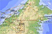
II. Northeastern Borneo This map shows the places we visited on Borneo. We have divided the journey into four parts, as shown on the map. We have also drawn our route in different colours for different types of transportation. |
|
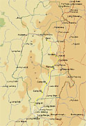
III. Kelabit Highlands This map shows our rainforest trek between Long Banga and Bario. Our route is well marked, including the detour to Long Beruang we had to do to get guides. From Long Banga there is an abandoned logging road almost all the way to Ramudu, but the truck could not go further than to Camp #1. From there, it was a three days walk to Ramudu and then another two days to Bario on wet, slippery and leech-covered trails between longhouse villages. |
| © 2001-2002 • Graphics Nicklas Nordborg • Texts and sounds Nicklas Nordborg |